Home
Weather Delhi
WeatherRadar
RainRadar
TemperatureRadar
WindRadar
LightningRadar
Weather News
Editor's Pick
Discover the app
Weather widget
Contact us
Apps
    Home / Editor's Pick /

    Heat dome - Trapped beneath a blanket of hot air

11:21 am
26 June 2026

Heat dome
High Heat Witnessed in Europe

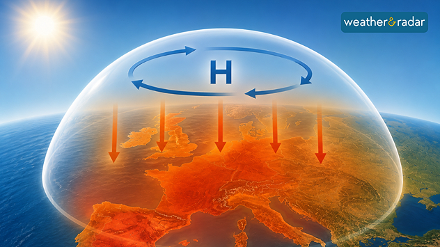
A strong area of high pressure has been hovering over south-western Europe for days. In many places, temperatures are reaching or even exceeding 40 °C due to what is known as a "heat dome".

However, the situation is particularly extreme not only because of the high temperatures, but because of their duration. Together with a persistent high-pressure system, the heat dome sits over the affected regions like a huge atmospheric bell.

Within what is known as a ‘heat dome’, hot air is trapped as if by an invisible dome.

It acts like an invisible lid over the atmosphere. The air, heated by the strong June sunshine, can barely escape and is further compressed and warmed by the high air pressure. Behind it lies a stable omega block, which keeps other weather systems at bay.

As a result, the heat can linger for days, sometimes even weeks. The current heatwave stretches from Spain through France to the UK and Germany. On the TemperatureRadar, the red and purple colours clearly show that the hot air mass is barely moving.

Jürgen Vollmer
More on the topic
Rain Hampers Search for Missing Persons. After the Flash Floods. . Extreme Weather. Wednesday, 2 September 2026
Extreme WeatherWednesday, 2 September 2026

After the Flash Floods

Rain Hampers Search for Missing Persons
Taking Images during Adverse Weather. Safety & Photography. . . Saturday, 12 September 2026
Jaipur lightning
Saturday, 12 September 2026

Safety & Photography

Taking Images during Adverse Weather
Super Typhoon Near The Philippines. Gusts of up to 155 mph. . . Wednesday, 24 June 2026
Wednesday, 24 June 2026

Gusts of up to 155 mph

Super Typhoon Near The Philippines
All weather news
This might also interest you
Low Pressure Developing Over the BoB. Cyclone next week?. . . Friday, 18 September 2026
Wind map showing low pressure over the Bay of Bengal, with cyclonic circulation and stronger winds reaching 40 kph near Sri Vijaya Puram.
Friday, 18 September 2026

Cyclone next week?

Low Pressure Developing Over the BoB
Sudden Evening Showers Can Disrupt Commutes. Travel Safely During Rain. . . Saturday, 12 September 2026
Heavy bursts of rain can quickly lead to waterlogging, slippery roads, reduced visibility and slower traffic.
Saturday, 12 September 2026

Travel Safely During Rain

Sudden Evening Showers Can Disrupt Commutes
Essential Weather & Radar Features. Stay Monsoon Ready. . . Wednesday, 16 September 2026
Wednesday, 16 September 2026

Stay Monsoon Ready

Essential Weather & Radar Features
All articles
Weather & Radar

Weather & Radar is also available on

Google Play StoreApp Store

Company

Contact us Privacy policy Legal info Accessibility statement

Services

Uploader

Socials

instagramfacebooktwitterlinkList