Home
Weather Delhi
WeatherRadar
RainRadar
TemperatureRadar
WindRadar
LightningRadar
Weather News
Editor's Pick
Discover the app
Weather widget
Contact us
Apps
    Home / Weather News /

    Western Disturbance to Trigger Rain and Snow
09:00 am
18 February 2026

Weather Update
Western Disturbance to Trigger Rain and Snow

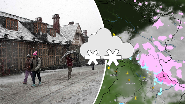
Another western disturbance over Himachal Pradesh

A fresh Western Disturbance is set to impact the Western Himalayan region, bringing rain and snowfall over the next few days.

Jammu & Kashmir, Himachal Pradesh and parts of Uttarakhand are likely to witness light to moderate rain in lower areas and fresh snowfall in the higher reaches.

Shimla

Sa
13
20
Su
13
20
Mo
14
20
Tu
13
18
We
13
16
Th
12
17
Fr
10
17
Sa
10
18
Su
10
16
Mo
12
18
Tu
13
18
We
14
18
Th
13
18
Fr
13
18
Max (°C)
Min (°C)
moreless

Hill stations may see cloudy skies with occasional showers. Temperatures are expected to drop slightly due to cloud cover and precipitation.

This system may also lead to travel disruptions in high-altitude areas. Residents and tourists are advised to follow local weather updates and advisories.

More on the topic
Third Warmest April on Record. Record in Spain. . . Saturday, 9 May 2026
Saturday, 9 May 2026

Record in Spain

Third Warmest April on Record
Temperatures Above 25°C in Northern Europe. Europe Heat Contrast. . . Saturday, 6 June 2026
Saturday, 6 June 2026

Europe Heat Contrast

Temperatures Above 25°C in Northern Europe
Super Typhoon Near The Philippines. Gusts of up to 155 mph. . . Wednesday, 24 June 2026
Wednesday, 24 June 2026

Gusts of up to 155 mph

Super Typhoon Near The Philippines
All weather news
This might also interest you
Active Storms as Monsoon Nears Its End. From West to East. . . Thursday, 17 September 2026
Weather map showing widespread thunderstorms and frequent lightning across northern and eastern India, especially from Jabalpur toward Kolkata and Bhubaneswar.
Thursday, 17 September 2026

From West to East

Active Storms as Monsoon Nears Its End
Super El Niño Strengthens. Impact on India?. . . Monday, 28 September 2026
Monday, 28 September 2026

Impact on India?

Super El Niño Strengthens
Deep depression over the Bay of Bengal. Flooding possible. . . Tuesday, 22 September 2026
Wind map showing a compact low near Visakhapatnam, with heavy rain and strong wind warning symbols and winds of 40–45 km/h across eastern India.
Tuesday, 22 September 2026

Flooding possible

Deep depression over the Bay of Bengal
All articles
Weather & Radar

Weather & Radar is also available on

Google Play StoreApp Store

Company

Contact us Privacy policy Legal info Accessibility statement

Services

Uploader

Socials

instagramfacebooktwitterlinkList