Home
Weather Delhi
WeatherRadar
RainRadar
TemperatureRadar
WindRadar
LightningRadar
Weather News
Editor's Pick
Discover the app
Weather widget
Contact us
Apps
    Home / Weather News /

    Active Weather Grips Northern Parts

08:00 am
7 April 2026

Widespread Alerts
Active Weather Grips Northern Parts

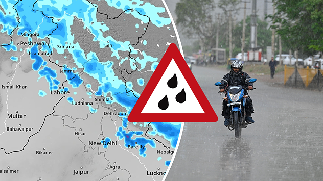
Western disturbance brings active weather in the north

A western disturbance is set to bring widespread rain, thunderstorms, and gusty winds across northwest and western India until April 9.

Some areas may witness intense activity with hail and stormy winds. Eastern regions will also see scattered showers and thunderstorms, while rain continues in the Northeast through the week.

Delhi

Mo
25
36
Tu
26
34
We
25
32
Th
24
33
Fr
25
31
Sa
23
31
Su
24
31
Mo
25
33
Tu
26
34
We
26
34
Th
27
34
Fr
25
34
Sa
26
34
Su
26
34
Max (°C)
Min (°C)
moreless

On Wednesday, central and northern India may experience heavy showers with unstable weather persisting in the east and northwest.

Madhya Pradesh and Maharashtra could face strong winds and some rainy conditions.

Temperatures across North India will drop sharply before rising again later in the week. Meanwhile, southern regions will remain hot, with temperatures staying above normal and only isolated showers expected.

More on the topic
Temperatures Above 25°C in Northern Europe. Europe Heat Contrast. . . Saturday, 6 June 2026
Saturday, 6 June 2026

Europe Heat Contrast

Temperatures Above 25°C in Northern Europe
Third Warmest April on Record. Record in Spain. . . Saturday, 9 May 2026
Saturday, 9 May 2026

Record in Spain

Third Warmest April on Record
Taking Images during Adverse Weather. Safety & Photography. . . Saturday, 12 September 2026
Jaipur lightning
Saturday, 12 September 2026

Safety & Photography

Taking Images during Adverse Weather
All weather news
This might also interest you
Deep Depression Brings Extreme Rainfall. Flooding and Landslides. . . Thursday, 24 September 2026
After the tropical depression made landfall on Wednesday, it will dominate the weather across much of eastern and central India over the coming days
Thursday, 24 September 2026

Flooding and Landslides

Deep Depression Brings Extreme Rainfall
Deep depression over the Bay of Bengal. Flooding possible. . . Tuesday, 22 September 2026
Wind map showing a compact low near Visakhapatnam, with heavy rain and strong wind warning symbols and winds of 40–45 km/h across eastern India.
Tuesday, 22 September 2026

Flooding possible

Deep depression over the Bay of Bengal
Monsoon Withdrawal to Pick Up Pace. End of Rainy Weather. . . Tuesday, 29 September 2026
The southwest monsoon withdrawal is expected to accelerate after a brief pause.
Tuesday, 29 September 2026

End of Rainy Weather

Monsoon Withdrawal to Pick Up Pace
All articles
Weather & Radar

Weather & Radar is also available on

Google Play StoreApp Store

Company

Contact us Privacy policy Legal info Accessibility statement

Services

Uploader

Socials

instagramfacebooktwitterlinkList