Home
Weather Delhi
WeatherRadar
RainRadar
TemperatureRadar
WindRadar
LightningRadar
Weather News
Editor's Pick
Discover the app
Weather widget
Contact us
Apps
    Home / Editor's Pick /

    Damage and fatalities: Typhoon RAGASA wreaks havoc in Southeast Asia

11:24 am
24 September 2025

Heavy Damage, Lives Lost
Typhoon RAGASA Batters Southeast Asia

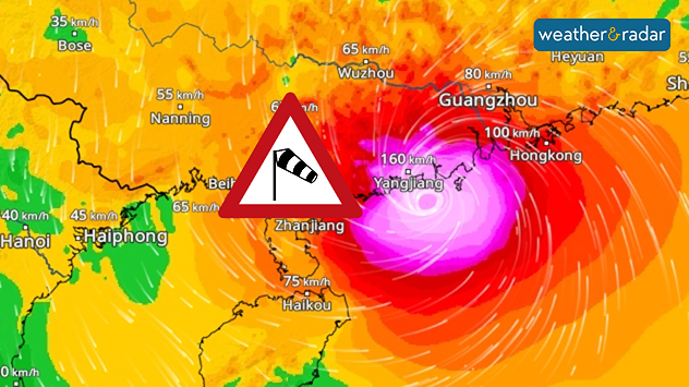
WindRadar shows wind speeds exceeding 150 kilometres per hour on the coast of China
WindRadar: Typhoon RAGASA hits the south coast of China with wind speeds between 150 and 200 kilometres per hour.

Super Typhoon RAGASA has caused destruction across Southeast Asia. The storm first hit the Philippines and Taiwan, where strong winds above 200 km/h and huge waves damaged houses, flooded coastal areas, and sadly killed more than 20 people.

Now, the cyclone has reached Hong Kong and southern China. In Guangdong province, over one million people have been moved to safer places. Hong Kong, too, has almost completely shut down as the storm passes.

RAGASA is currently a very powerful typhoon, the second-highest category, and will stay dangerous while moving west along the Chinese coast. It is expected to weaken slowly only after moving inland.

Super Typhoon RAGASA continues to move onWindRadar
Dr. Bernd Maurer
More on the topic
Rain Hampers Search for Missing Persons. After the Flash Floods. . Extreme Weather. Wednesday, 2 September 2026
Extreme WeatherWednesday, 2 September 2026

After the Flash Floods

Rain Hampers Search for Missing Persons
High Heat Witnessed in Europe. Heat dome. . . Friday, 26 June 2026
Friday, 26 June 2026

Heat dome

High Heat Witnessed in Europe
Temperatures Above 25°C in Northern Europe. Europe Heat Contrast. . . Saturday, 6 June 2026
Saturday, 6 June 2026

Europe Heat Contrast

Temperatures Above 25°C in Northern Europe
All weather news
This might also interest you
Low Pressure Developing Over the BoB. Cyclone next week?. . . Friday, 18 September 2026
Wind map showing low pressure over the Bay of Bengal, with cyclonic circulation and stronger winds reaching 40 kph near Sri Vijaya Puram.
Friday, 18 September 2026

Cyclone next week?

Low Pressure Developing Over the BoB
Sudden Evening Showers Can Disrupt Commutes. Travel Safely During Rain. . . Saturday, 12 September 2026
Heavy bursts of rain can quickly lead to waterlogging, slippery roads, reduced visibility and slower traffic.
Saturday, 12 September 2026

Travel Safely During Rain

Sudden Evening Showers Can Disrupt Commutes
Active Storms as Monsoon Nears Its End. From West to East. . . Thursday, 17 September 2026
Weather map showing widespread thunderstorms and frequent lightning across northern and eastern India, especially from Jabalpur toward Kolkata and Bhubaneswar.
Thursday, 17 September 2026

From West to East

Active Storms as Monsoon Nears Its End
All articles
Weather & Radar

Weather & Radar is also available on

Google Play StoreApp Store

Company

Contact us Privacy policy Legal info Accessibility statement

Services

Uploader

Socials

instagramfacebooktwitterlinkList