Home
Weather Delhi
WeatherRadar
RainRadar
TemperatureRadar
WindRadar
LightningRadar
Weather News
Editor's Pick
Discover the app
Weather widget
Contact us
Apps
    Home / Weather News /

    Deep depression over the Bay of Bengal

08:53 am
22 September 2026

Flooding possible
Deep depression over the Bay of Bengal

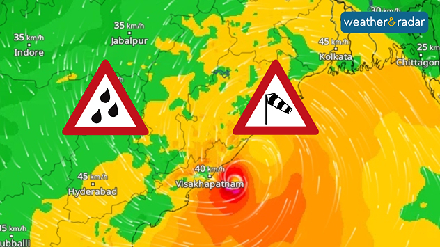
Wind map showing a compact low near Visakhapatnam, with heavy rain and strong wind warning symbols and winds of 40–45 km/h across eastern India.
An active WindRadar as a deep depression forms over the Bay of Bengal.

The powerful low-pressure system over the Bay of Bengal has intensified into a deep depression over the past few hours. It is currently located near the coasts of Odisha and Andhra Pradesh and is expected to make landfall on Wednesday.

Heavy rainfall is expected especially across Odisha, parts of Andhra Pradesh and Telangana, Chhattisgarh, West Bengal, and Jharkhand, with very heavy rainfall possible locally. High rainfall totals may occur in some areas, bringing a risk of flooding.

In addition to the rain, strong winds are also expected, with widespread wind speeds of 50–70 kph and gusts of up to 100 kph along the coast.

People in these regions should remain alert and pay attention to local warnings. Later in the week, the rainfall will also spread into eastern Madhya Pradesh, eastern Uttar Pradesh, and Bihar.

Weather & Radar editorial desk
More on the topic
Third Warmest April on Record. Record in Spain. . . Saturday, 9 May 2026
Saturday, 9 May 2026

Record in Spain

Third Warmest April on Record
Super Typhoon Near The Philippines. Gusts of up to 155 mph. . . Wednesday, 24 June 2026
Wednesday, 24 June 2026

Gusts of up to 155 mph

Super Typhoon Near The Philippines
Taking Images during Adverse Weather. Safety & Photography. . . Saturday, 12 September 2026
Jaipur lightning
Saturday, 12 September 2026

Safety & Photography

Taking Images during Adverse Weather
All weather news
This might also interest you
Sudden Evening Showers Can Disrupt Commutes. Travel Safely During Rain. . . Saturday, 12 September 2026
Heavy bursts of rain can quickly lead to waterlogging, slippery roads, reduced visibility and slower traffic.
Saturday, 12 September 2026

Travel Safely During Rain

Sudden Evening Showers Can Disrupt Commutes
Active Storms as Monsoon Nears Its End. From West to East. . . Thursday, 17 September 2026
Weather map showing widespread thunderstorms and frequent lightning across northern and eastern India, especially from Jabalpur toward Kolkata and Bhubaneswar.
Thursday, 17 September 2026

From West to East

Active Storms as Monsoon Nears Its End
Heavy Rain Unlikely in Mumbai. September Weather. . . Wednesday, 9 September 2026
Weather in Mumbai likely to remain dry
Wednesday, 9 September 2026

September Weather

Heavy Rain Unlikely in Mumbai
All articles
Weather & Radar

Weather & Radar is also available on

Google Play StoreApp Store

Company

Contact us Privacy policy Legal info Accessibility statement

Services

Uploader

Socials

instagramfacebooktwitterlinkList